Kota Belud
Pengitoon
(Pinejurus lua’ Kuta Belud)
Kota Belud | |
|---|---|
Town and district capital | |
| Pekan Kota Belud (Kota Belud Town | |
| Other transcription(s) | |
| • Jawi | كوتا بلود |
| • Chinese | 古打毛律 (Simplified) 古打毛律 (Traditional) Gǔdǎ Máolǜ (Hanyu Pinyin) Kó͘-táⁿ Môo-lu̍t (Hokkien POJ) Gu2 Daa1 Mou4 Leot6 (Cantonese Jyutping) Kú-tá Mâu-lu̍t (Hakka Pha̍k-fa-sṳ) |
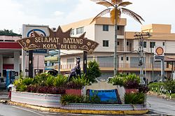
 Gateway marking the southern entrance to Kota Belud. | |
 | |
| Coordinates: 6°21′00″N 116°26′00″E / 6.35000°N 116.43333°E | |
| Country | |
| State | |
| Division | West Coast |
| District | Kota Belud |
| Area | |
| • Total | 1,385.6 km2 (535.0 sq mi) |
| Population (2010) | |
| • Total | 8,392 |
| Tamu (Weekly Market) | Sunday |
Kota Belud dembua pekan ko’ daerah tak’ bahagian pantai barat sabah Daerah Kota Belud tu pan sebuo pantadbiran awal paling toh’ tak negeri sabah.diam penduduk kerajaan british.

